Mt. Vitet Adventure

DaveM

SBH Insider
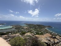
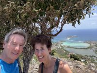
Vicki and I were delighted to be able to find our way to the top of Mt Vitet recently . . . it was a longtime curiosity and we were well rewarded with lucky weather and spectacular views!

It’s not an easy trail, but doable for the determined! Took about an hour and a half overall.
 

Attachments

  • IMG_7696.jpeg
    IMG_7696.jpeg
    3.2 MB · Views: 197
  • IMG_7704.jpeg
    IMG_7704.jpeg
    2.3 MB · Views: 224
  • IMG_7708.jpeg
    4.5 MB · Views: 60
From which side did you begin the trek ? Toiny ?
The trail begins on the uphill side of the road leading away from camaruche. Coming out of lorient at the top of the hill you turn right then keep going for a while in the direction of toiny/petit cul de sac.
 
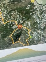
The taxi dropped us off at the green circle and picked us up at the red circle. There is no parking. But now that we did the whole loop I would just go up and then back down the same first half of the loop. The views on the second half are not worth the bushwhacking and with no colored dots to indicate the trail, it is much more difficult route finding. There were easy red dots going up that can be followed right back down the same route back to the green circle.
 

Attachments

  • IMG_7657.jpeg
    IMG_7657.jpeg
    2 MB · Views: 165
Capture d’écran 2026-06-10 à 10.48.16 AM.png

Did you have a guide? We have stayed in Vitet for many years and have tried to spot anything resembling a trailhead but have never seen such. Plus, I believe all that is private property ???
 
If you drive to the green circle you will see that the road ends and a path begins. I used the hiking application called All Trails. It shows the first part of the trail, and from this you can begin spotting the red marker dots. Yes, we saw an old private property sign, and were prepared to accept a measure of justice if necessary. The sign was deep in the woods. It never felt like we were walking across anyone’s home.
 
I've previously written this story, so apologies to anyone who's asking, "Haven't I read this before?"

My experience in climbing to the top of Mt. Vitet was in the mid-80s, as I came to know Hubert de la Motte (now shortened to Delamotte) while frequently dining in the charming, rustic dining room of his Hostellerie des Trois Forces . . . located approximately where Vitet turns into Devet. When closed on a Sunday afternoon, Hubert invited me to join him with one of his young sons, Apollon, and the then-Director of the SBH Bureau of Tourism, Elise Magras, to climb Mt. Vitet. As I recall, we briefly drove into Devet and turned right onto a short "stub road," where we parked at its dead end . . . and started our hike.

In the beginning, there clearly was a trail . . . which, intermittently, disappeared at times into dense brush and foliage (much of it very pretty . . . such as wild orchids in bloom). The hike was made easier as Apollon -- probably about 5 years old -- playfully and charmingly, as children can be, ran ahead, circling back to guide us along the trail as he tracked it.

Unfortunately, I was -- characteristically to this day -- dressed in shorts, which meant that branches and other vegetation left a lot of scratches on my legs. In 3+ hours, I also presented a fertile feeding ground for mosquitoes. Nonetheless, the view at top was exciting and quite memorable . . . as I made lifelong friends in the adventure. (About a month ago, e.g., when in Marché U, a quiet voice asked, "Mr. Carlton?" -- it was Apollon, now all grown-up & a professional chef on the island -- https://www.lofficielstbarth.com/food/food-is-love. He's still as winsome and endearing as he was at five years!)
 
I've previously written this story, so apologies to anyone who's asking, "Haven't I read this before?"

My experience in climbing to the top of Mt. Vitet was in the mid-80s, as I came to know Hubert de la Motte (now shortened to Delamotte) while frequently dining in the charming, rustic dining room of his Hostellerie des Trois Forces . . . located approximately where Vitet turns into Devet. When closed on a Sunday afternoon, Hubert invited me to join him with one of his young sons, Apollon, and the then-Director of the SBH Bureau of Tourism, Elise Magras, to climb Mt. Vitet. As I recall, we briefly drove into Devet and turned right onto a short "stub road," where we parked at its dead end . . . and started our hike.

In the beginning, there clearly was a trail . . . which, intermittently, disappeared at times into dense brush and foliage (much of it very pretty . . . such as wild orchids in bloom). The hike was made easier as Apollon -- probably about 5 years old -- playfully and charmingly, as children can be, ran ahead, circling back to guide us along the trail as he tracked it.

Unfortunately, I was -- characteristically to this day -- dressed in shorts, which meant that branches and other vegetation left a lot of scratches on my legs. In 3+ hours, I also presented a fertile feeding ground for mosquitoes. Nonetheless, the view at top was exciting and quite memorable . . . as I made lifelong friends in the adventure. (About a month ago, e.g., when in Marché U, a quiet voice asked, "Mr. Carlton?" -- it was Apollon, now all grown-up & a professional chef on the island -- https://www.lofficielstbarth.com/food/food-is-love. He's still as winsome and endearing as he was at five years!)
Grown up & quite handsome too ! loved your story Dennis!
 
Great story!
Dined at Trois Forces once many years ago with friends and Hubert did a brief astrology read for us. A few years later, I believe 2011, he and his wife cooked for us at our villa. A very nice man as I recall. Happy to hear his son is also an island chef.
Thank you Dennis.
 
The taxi dropped us off at the green circle and picked us up at the red circle. There is no parking. But now that we did the whole loop I would just go up and then back down the same first half of the loop. The views on the second half are not worth the bushwhacking and with no colored dots to indicate the trail, it is much more difficult route finding. There were easy red dots going up that can be followed right back down the same route back to the green circle.
We're interested in trying this hike when we visit...

You think it would be OK to park in or near that green circle? Just start there and look for the red dots? Up and back from there 90 minutes? Need to wear pants or shorts OK?

Thanks!
 
We are always concerned with treating property owners with respect. Practically the entire island is private land, which means any and all hiking is technically trespassing.

We try to stick to well‑established paths, but even those can change abruptly. Colombier is a good example, and more recently Toiny's around the rock. Not to mention last summer’s emergency helicopter evacuation in Grand Fond. One must tread carefully.

This hike is indeed tempting. We hope to experince as well.
 
it's very unFrench to not have publicly accessible hiking trails. in France métropolitaine there are many 10's of 1000's of kilometers of sentiers open to the public.

the recent trottoir campaign is more important and useful, but establishing a network of hiking trails would be very cool 😎
 
We're interested in trying this hike when we visit...

You think it would be OK to park in or near that green circle? Just start there and look for the red dots? Up and back from there 90 minutes? Need to wear pants or shorts OK?

Thanks!
Long pants recommended . . . a lot of prickly vegetation & mosquitoes along the route. 90 minutes would be an ambitious plan.
 
We're interested in trying this hike when we visit...

You think it would be OK to park in or near that green circle? Just start there and look for the red dots? Up and back from there 90 minutes? Need to wear pants or shorts OK?

Thanks!
There is no parking near the green circle. I suggest taxi to the green circle. Have taxi come back or wait for your return in 90-120 mins. Taxi was a bit costly but worth it as a perfect solution to the no parking uncertainties/worries. Follow the trail ten minutes until you see the first red dot. Then go to summit. Look around. Then go back down the red dot path you just came up. No need to do the whole loop shown on the map, the dots disappear trying to go the whole loop. So you’re bushwhacking. You could wear shorts ( I did) if you prefer cooler clothing and just be careful about the low bushes.
 
Vicki and I were delighted to be able to find our way to the top of Mt Vitet recently . . . it was a longtime curiosity and we were well rewarded with lucky weather and spectacular views!

It’s not an easy trail, but doable for the determined! Took about an hour and a half overall.
vitet hike is very good, however, the best hike on the island is the chauvette hike with the blue stones beach on the way to saline.
 
Top