I've previously written this story, so apologies to anyone who's asking, "Haven't I read this before?"
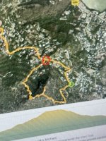
My experience in climbing to the top of Mt. Vitet was in the mid-80s, as I came to know Hubert de la Motte (now shortened to Delamotte) while frequently dining in the charming, rustic dining room of his Hostellerie des Trois Forces . . . located approximately where Vitet turns into Devet. When closed on a Sunday afternoon, Hubert invited me to join him with one of his young sons, Apollon, and the then-Director of the SBH Bureau of Tourism, Elise Magras, to climb Mt. Vitet. As I recall, we briefly drove into Devet and turned right onto a short "stub road," where we parked at its dead end . . . and started our hike.
In the beginning, there clearly was a trail . . . which, intermittently, disappeared at times into dense brush and foliage (much of it very pretty . . . such as wild orchids in bloom). The hike was made easier as Apollon -- probably about 5 years old -- playfully and charmingly, as children can be, ran ahead, circling back to guide us along the trail as he tracked it.
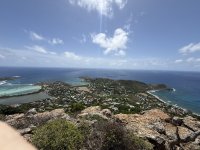
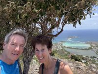
Unfortunately, I was -- characteristically to this day -- dressed in shorts, which meant that branches and other vegetation left a lot of scratches on my legs. In 3+ hours, I also presented a fertile feeding ground for mosquitoes. Nonetheless, the view at top was exciting and quite memorable . . . as I made lifelong friends in the adventure. (About a month ago, e.g., when in Marché U, a quiet voice asked, "Mr. Carlton?" -- it was Apollon, now all grown-up & a professional chef on the island --
https://www.lofficielstbarth.com/food/food-is-love. He's still as winsome and endearing as he was at five years!)