Intriguing weather in 2018

Status
Not open for further replies.
DdUs7r_WAAM-G8W.jpg

A really great cover for NG
 
April 2018 was the planet's third-warmest April since record keeping began in 1880, said NOAA's National Centers for Environmental Information (NCEI) on Thursday. NASA also rated April 2018 as the third-warmest April on record. Both agencies found that the only warmer April months were in 2016 and 2017. Occasional differences in rankings between NASA and NOAA are mostly due to how they handle data-sparse regions such as the Arctic, where few surface weather stations exist.The rankings for April were cooler than we've seen in the last couple of years largely because of the presence of colder weather than average over most of North America, plus the presence of cool ocean temperatures over the Eastern Pacific from a weak La Niña event that ended in April.

Business as usual ))
 
Arctic sea ice extent during April 2018 was the second lowest in the 40-year satellite record, behind the record set in April 2017, according to the National Snow and Ice Data Center (NSIDC).

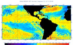
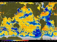
Oceans are also warming worldwide.(but no need to prepare for stronger hurricanes ..according to some geniuses )
 
anomw.5.17.2018.jpgsst_anom.jpg

Logical consequence

[FONT=&quot]The 2018 Atlantic hurricane season is expected to feature a near-average number of hurricanes and tropical storms, according to an updated seasonal outlook released by The Weather Company, an IBM Business.
([/FONT]
[FONT=&quot]This is slightly less activity compared to the April outlook, which called for 13 named storms and six hurricanes this hurricane season)[/FONT]
 
IMG_4616.jpg

A clear sign St Barth has turned a corner)
Absolutely incredible weather for the moment on the island....Lovely blue sky,few clouds and showers,and idyllic temperatures.
Paradise is BACK
 
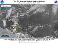
two_atl_2d0.jpg

A new system appearing ...Bringing heavy rain later this week .Keep an eye on it as GOM is warm

62341c7bc2ec4655957da2edc0bff1ee.jpg

An extraordinary photo of Hawaii...Incredible to see those immense flows of lava,destroying houses,highways.

TS Sagar did major damage in Somalia,Massive rain was also reported
And Oman is facing a cat 4 hurricane this week....
Interestingly,this should trigger a major locust invasion/eruption later on.

In St Barth,no end in sight to the fabulous weather for the moment:blue sky and fresh temperature .Just paradise.The island looks sensationnal.And no sargassum.
 
anomw.5.21.2018.jpganoma.5.21.2018.jpg

The usual update for those following the SSTs and the heat content.
Looking rather positive for the moment .
Please also note that the sargasses have disappeared for the moment.
 
Delicious looking Lobsters. Hope you are enjoying your time in Paradise!

Thanks...amazing days in paradise....sublime weather,great food,and seeing the island coming back to life is just lovely.Traffic jam,construction,noise,crowded bars (for may)...the vibrant island is back

And news is improving

sst_anom.jpg
 
Chris . . . it looks like you've been eating at "The Fish Corner." Great spot, isn't it!

Absolutely...a fine example of a vibrant island,attracting talents and investors,bringing competition and higher quality for all visitors.
It would be great to have something similar on the beach,now that Gloriette is gone.Cold raw fish for lunch,just perfect.
 
[FONT=Lato, Helvetica Neue, Helvetica, Arial, sans-serif] New forecast out ....ewwwww[/FONT]

[FONT=Lato, Helvetica Neue, Helvetica, Arial, sans-serif]Meteorologists at the National Oceanic and Atmospheric Administration said they are forecasting 10-16 named storms this year, and five to nine of those storms are forecast to become hurricanes. One to four of the hurricanes are forecast to become major, meaning Category 3 or higher.

Lots of uncertainty because of potential El nino and NAO picking up.
[/FONT]
 
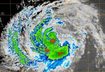
20180524.0930.msg1_.x.ir1km.02AMEKUNU.80kts-971mb-137N-555E.100pc.jpg

Mekunu coming to Oman....all my thoughts are with the people there.

Very warm sea-surface temperatures of 30-32°C (86-90°F) will favor intensification on Thursday. Warm waters extended to great depth along the path of the storm, giving Mekunu a tropical cyclone heat potential in excess of 100 kilojoules per square centimeter—the kind of heat content often seen leading to rapid intensification. Wind shear is expected to remain moderate, around 15 knots.

 
two_atl_2d0.jpg

Something to follow as the water in the GOM is really warm for the season.
80% to become a TS within 5 days according to NHC
 
For those keeping track of the data

The latest monthly NOAA/IRI probabilistic ENSO forecast, issued May 18, calls for approximately a 45% chance of El Niño conditions during the peak August-September-October period of the Atlantic hurricane season.

Fingers crossed...El
niño will kick in.
 
Status
Not open for further replies.
Top