You are using an out of date browser. It may not display this or other websites correctly.
You should upgrade or use an alternative browser.
You should upgrade or use an alternative browser.
Next week could be interesting
- Thread starter BBT
- Start date
stbartshopper
Senior Insider
One never wants to hear from a doctor who is examining you saying- 'this is interesting.' We like boredom- keep the storms away!


BBT
Senior Insider
[h=1]99L and 90L May Soon Develop in Atlantic; Fiona Clings to Life[/h]
By: Jeff Masters and Bob Henson , 4:28 PM GMT on August 21, 2016
A large but nearly thunderstorm-free tropical wave (Invest 99L) was located in the tropical Atlantic about 1100 miles east of the Lesser Antilles Islands late Sunday morning, and was headed west at 15 - 20 mph. This disturbance is not likely to develop into a tropical depression or tropical storm before moving into the Lesser Antilles Islands on Tuesday night, but will bring some heavy rains and gusty winds to the islands on Tuesday and Wednesday. The storm could be a long-range threat to the U.S. East Coast from Florida northwards in about 7 - 10 days.
The most impressive thing about 99L when viewing satellite loops is its very large size and excellent spin. A large region of the atmosphere has been put in motion by this disturbance, which is both good news and bad news: good news because such large disturbances typically take a long time to spin up into a tropical cyclone, but bad news because once they do, they affect a large area and will resist rapid weakening. The other notable feature of the storm on Sunday morning was the lack of heavy thunderstorm activity, due to dry air from the Saharan Air Layer (SAL), as seen in water vapor satellite imagery. However, this dry air was only moderately dry, with humidities at mid-levels of the atmosphere between 500 - 700 mb running about 60%, and the circulation of 99L was getting more defined late Sunday morning, potentially signaling that the storm might be about to build some heavy thunderstorms near its center. Other conditions were generally favorable for development, with wind shear a moderate 10 - 15 knots and sea surface temperatures (SSTs) near 27.5°C (82°F), which was close to average.
BBT
Senior Insider
Wonderful.Tuesday report at 3:30 pm. Weather is sunny and beautiful
BBT
Senior Insider
Satellite loops on Tuesday morning showed that heavy thunderstorm activity associated with 99L had slowly increased over the the previous 24 hours. The storm was still poorly organized, though, with no surface circulation center apparent and few low-level spiral bands. Upper-level cirrus clouds streaming away from the northeast side of the storm gave evidence that an upper-level outflow channel was trying to develop, however. Dry air from the Saharan Air Layer (SAL) that has been interfering with development over the past few days had decreased, as seen on water vapor satellite imagery. Wind shear was marginally favorable for development, at 10 - 15 knots, and sea surface temperatures (SSTs) were favorable for development: 28.5 - 29°C (83 - 84°F) (about 0.5°C above average.)

Figure 1. Latest satellite image of 99L.
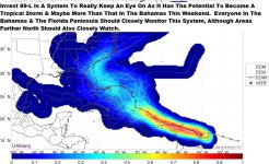
Track forecast: 99L likely to affect the Bahamas and Southeast U.S.
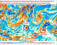
A strong ridge of high pressure will keep 99L headed west-northwest over the next few days, and the storm will traverse the northern Lesser Antilles Tuesday night through Wednesday, track close to or just north of Puerto Rico on Wednesday night, then reach the Southeastern Bahamas by Thursday. At this time, the models keep 99L far enough north of the island of Hispaniola to prevent the high mountains there from significantly disrupting 99L. However, we cannot have confidence in this forecast until 99L develops a well-defined center that the models can track. Due to its large size, 99L will be capable of bringing torrential rains and flash flooding and mudslides to the Dominican Republic and Haiti. The uncertainty about the track increases greatly on Friday and into the weekend, due to a potential weakness in the ridge of high pressure steering the storm caused by a trough of low pressure passing to the north of 99L. The storm should slow its forward motion to 5 - 10 mph Friday through Saturday, in response to this trough, and may turn to the northwest or north near the central Bahamas. Over 80% of the ensemble members from the 00Z Tuesday runs of the European and GFS models show 99L hitting the Southeast U.S. between Florida and South Carolina sometime Sunday or later; very few show the storm missing the U.S. entirely. The track and intensity of 99L may be affected by the remnants of Tropical Storm Fiona, which NHC stopped issuing advisories on at 11 am EDT Tuesday. The remains of Fiona will be a few hundred miles to the north or northeast of 99L this weekend. Hurricane Gaston will be too far from 99L to exert a steering influence on it.
Figure 1. Latest satellite image of 99L.
Track forecast: 99L likely to affect the Bahamas and Southeast U.S.
A strong ridge of high pressure will keep 99L headed west-northwest over the next few days, and the storm will traverse the northern Lesser Antilles Tuesday night through Wednesday, track close to or just north of Puerto Rico on Wednesday night, then reach the Southeastern Bahamas by Thursday. At this time, the models keep 99L far enough north of the island of Hispaniola to prevent the high mountains there from significantly disrupting 99L. However, we cannot have confidence in this forecast until 99L develops a well-defined center that the models can track. Due to its large size, 99L will be capable of bringing torrential rains and flash flooding and mudslides to the Dominican Republic and Haiti. The uncertainty about the track increases greatly on Friday and into the weekend, due to a potential weakness in the ridge of high pressure steering the storm caused by a trough of low pressure passing to the north of 99L. The storm should slow its forward motion to 5 - 10 mph Friday through Saturday, in response to this trough, and may turn to the northwest or north near the central Bahamas. Over 80% of the ensemble members from the 00Z Tuesday runs of the European and GFS models show 99L hitting the Southeast U.S. between Florida and South Carolina sometime Sunday or later; very few show the storm missing the U.S. entirely. The track and intensity of 99L may be affected by the remnants of Tropical Storm Fiona, which NHC stopped issuing advisories on at 11 am EDT Tuesday. The remains of Fiona will be a few hundred miles to the north or northeast of 99L this weekend. Hurricane Gaston will be too far from 99L to exert a steering influence on it.