You are using an out of date browser. It may not display this or other websites correctly.
You should upgrade or use an alternative browser.
You should upgrade or use an alternative browser.
something headed our way?
- Thread starter didier
- Start date
Bart -my real name-
Senior Insider
Is it super dry again this year?
I hope so, too, Diana! Be safe
JEK
Senior Insider
stbartshopper
Senior Insider
In the case of continued extreme drought, can the desalinization plant handle all of the island's needs indefinitely, even though at a high cost to the users?
JEK
Senior Insider
JEK
Senior Insider
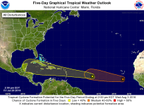
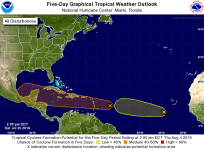
Looks like good rain even if it doesn't develop into a full TS.
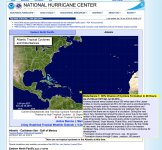
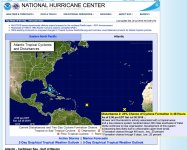
ZCZC MIATWOAT ALL
TTAA00 KNHC DDHHMM
TROPICAL WEATHER OUTLOOK
NWS NATIONAL HURRICANE CENTER MIAMI FL
200 PM EDT SAT JUL 30 2016
For the North Atlantic...Caribbean Sea and the Gulf of Mexico:
1. A strong tropical wave located about 550 miles east of the Lesser
Antilles is moving westward at 25 to 30 mph and is accompanied by
increasing shower activity. However, surface observations and
satellite wind data show that pressures are relatively high in the
area and that there are no signs of a circulation. During the next
day or two, development should be slow to occur due to the rapid
motion of the system. Regardless of development, this system will
likely bring locally heavy rains and gusty winds to portions of the
Leeward Islands, Virgin Islands, Puerto Rico, and Hispaniola, and
interests in these areas should monitor its progress. By the middle
of next week, the disturbance is expected to be in the western
Caribbean Sea, where conditions are likely to be more conducive for
development.
* Formation chance through 48 hours...low...30 percent
* Formation chance through 5 days...medium...60 percent
tim
Moderator
Headed to St. Bart's on August 6th...what's the current outlook?
Thanks
Adam
Adam, welcome to the forum! Has your question been answered satisfactorily?
KevinS
Senior Insider
Look for the possibility of 2+" (5+cm) of rain on SBH on Sunday from the first tropical wave.
It's really too early to comment on the 2nd tropical wave, which will reach the Caribbean later in the week. The usual computer models don't predict that far ahead. Keep an eye on a site such as Weather Underground. https://www.wunderground.com/hurricane/ At present, the tropical wave is still that, a tropical wave. What you want to keep an eye on is the wave which is presently designated 96L.
And yes, I would prepare for wet as JEK suggests, but I wouldn't have a "hunker down, it's a hurricane" mentality. I might add a rain hat to my bag, and perhaps even a rain slicker, but I personally wouldn't do much more than that, given what I see in the forecasts. If a tropical wave does come through, it will likely come and go in a day, so anyone vacationing next week is unlikely to have a washout.
I've had washouts (6 straight days of unending rain) in November. Attitude becomes important then. I was traveling with friends at the time, some of them hated it and had a terrible vacation, some of us adapted, figured out how to have fun in the rain, and moved on. The sun eventually came out, some went home as scheduled (my then-girlfriend with work responsibilities included), and some (me included) extended for an extra 3 days.


