
andynap
Senior Insider
Schwartz: Nor'easter could hit Jersey Shore
GLENN “HURRICANE” SCHWARTZ, NBC10 PHILADELPHIA
LAST UPDATED: Wednesday, August 5, 2015, 7:08 PM
Possible Nor'easter
Instead of a simple storm tracking south of the Philly area Friday, we may see something stronger, slower, windier, and wetter. And the area most affected would be the Jersey Shore and Delaware Beaches. Anyone planning a trip this weekend should be aware of possible changing forecasts (in any event, Sunday looks nice).
Which model to root for
As we’ve said many times, there are a lot of different computer forecast models, from all over the world. They show future weather patterns, and even specific things like temperatures and amounts of rain. When they all agree, we can have a lot of confidence in our forecasts. When they disagree, like now, we can do one of three things:
1. Pick the model we believe is going to be best
2. Take an average of the all the models
3. If the models fall into two different “camps” (for example, one tracking out to sea and one more up the coast), pick the general answer and then average the models in that “camp”.
It’s hard not to have a bias toward (or against) a particular model. Maybe it steered us wrong the last time, or it would require a drastic change in the existing forecast. Apparently, this happens with many other types of forecasting (sports, stocks, climate change, etc.), and it happens so often there’s even a name for it: “Confirmation Bias”. Our bias is to look for whatever solution agrees with our current forecast or belief. In this case, our last forecast was for nice weather Saturday. We then “root” for the models that still show that.
Which model is in which 'camp'?
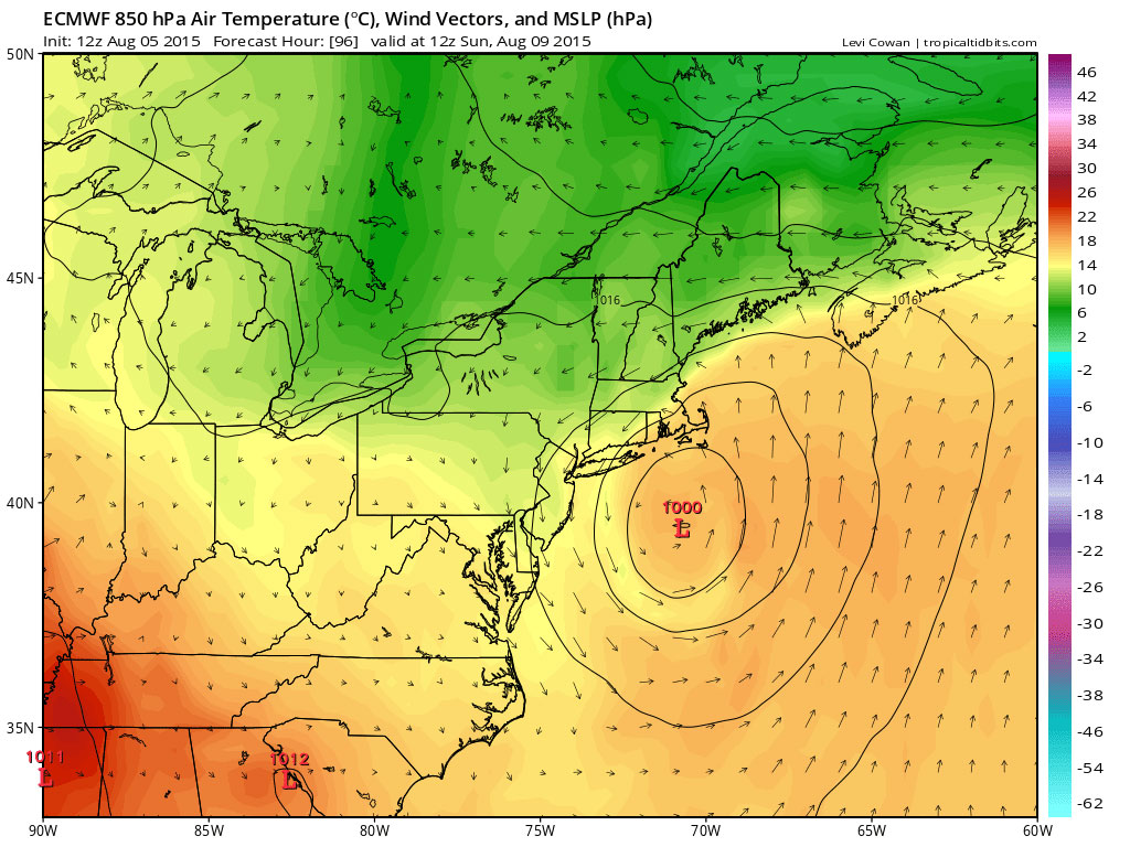
The world’s best model overall, as we all should know by now, is the European. It’s the best in general and best for Nor’easters. It does tend to get too extreme and too slow at times. We hope that’s the case now. In the EURO camp is the UKMET, SREF, and NAVGEM (and others). They all show a strong storm, moving slowly, that brings significant rain not only to the shore, but all the way to the Phila. area. They would keep the rain and wind in the area even into Saturday (“BOOOOOO”!). Here are a couple of EURO maps showing the general track of the LOW pressure area:
image: http://media.philly.com/images/weekend_map_1024.jpg
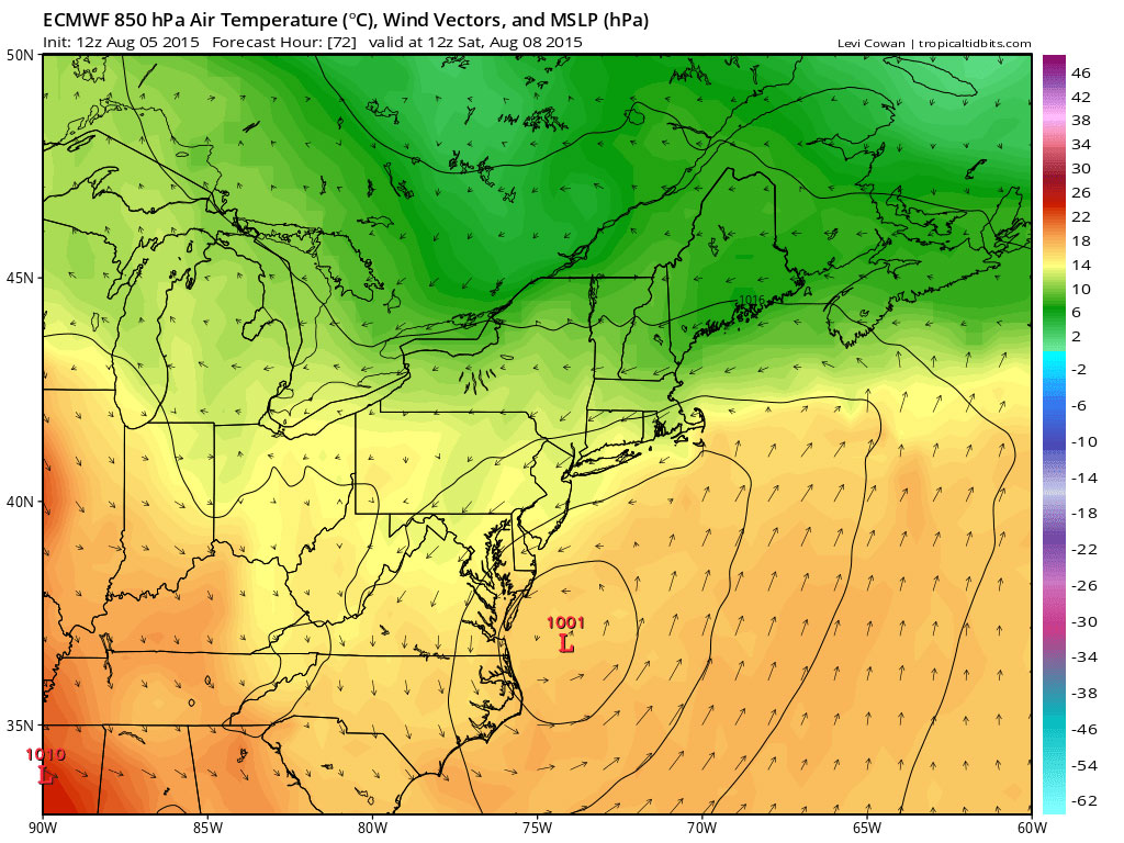
image: http://media.philly.com/images/weekend_map_1024_2.jpg
The other “camp” consists of the GFS, Canadian, RPM, JMA, and NAM (and others). They have the storm weaker and faster, and track it farther east. (“YEA!!!!!!”) If they’re right, the storm moves more out to sea, leaving us with a nice Saturday. Our “confirmation bias” wants this solution to be right for two reasons: it would be similar to yesterday’s forecast; and none of us like rain on summer weekends, especially at the shore.
The models are run every 3, 6 or 12 hours, depending on the model. So there are several model runs to go before the weekend. Feel free to root for your favorites.
Read more at http://www.philly.com/philly/news/Noreaster_could_hit_Jersey_Shore.html#64X1lBswZfDvKC1r.99
GLENN “HURRICANE” SCHWARTZ, NBC10 PHILADELPHIA
LAST UPDATED: Wednesday, August 5, 2015, 7:08 PM
Possible Nor'easter
Instead of a simple storm tracking south of the Philly area Friday, we may see something stronger, slower, windier, and wetter. And the area most affected would be the Jersey Shore and Delaware Beaches. Anyone planning a trip this weekend should be aware of possible changing forecasts (in any event, Sunday looks nice).
Which model to root for
As we’ve said many times, there are a lot of different computer forecast models, from all over the world. They show future weather patterns, and even specific things like temperatures and amounts of rain. When they all agree, we can have a lot of confidence in our forecasts. When they disagree, like now, we can do one of three things:
1. Pick the model we believe is going to be best
2. Take an average of the all the models
3. If the models fall into two different “camps” (for example, one tracking out to sea and one more up the coast), pick the general answer and then average the models in that “camp”.
It’s hard not to have a bias toward (or against) a particular model. Maybe it steered us wrong the last time, or it would require a drastic change in the existing forecast. Apparently, this happens with many other types of forecasting (sports, stocks, climate change, etc.), and it happens so often there’s even a name for it: “Confirmation Bias”. Our bias is to look for whatever solution agrees with our current forecast or belief. In this case, our last forecast was for nice weather Saturday. We then “root” for the models that still show that.
Which model is in which 'camp'?
The world’s best model overall, as we all should know by now, is the European. It’s the best in general and best for Nor’easters. It does tend to get too extreme and too slow at times. We hope that’s the case now. In the EURO camp is the UKMET, SREF, and NAVGEM (and others). They all show a strong storm, moving slowly, that brings significant rain not only to the shore, but all the way to the Phila. area. They would keep the rain and wind in the area even into Saturday (“BOOOOOO”!). Here are a couple of EURO maps showing the general track of the LOW pressure area:
image: http://media.philly.com/images/weekend_map_1024.jpg
image: http://media.philly.com/images/weekend_map_1024_2.jpg
The other “camp” consists of the GFS, Canadian, RPM, JMA, and NAM (and others). They have the storm weaker and faster, and track it farther east. (“YEA!!!!!!”) If they’re right, the storm moves more out to sea, leaving us with a nice Saturday. Our “confirmation bias” wants this solution to be right for two reasons: it would be similar to yesterday’s forecast; and none of us like rain on summer weekends, especially at the shore.
The models are run every 3, 6 or 12 hours, depending on the model. So there are several model runs to go before the weekend. Feel free to root for your favorites.
Read more at http://www.philly.com/philly/news/Noreaster_could_hit_Jersey_Shore.html#64X1lBswZfDvKC1r.99


