You are using an out of date browser. It may not display this or other websites correctly.
You should upgrade or use an alternative browser.
You should upgrade or use an alternative browser.
Heads Up Next Weekend
- Thread starter rolltide
- Start date
cassidain
Senior Insider

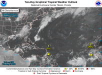
2. Eastern Tropical Atlantic:
A tropical wave has moved off the west coast of Africa and is
producing a large area of disorganized showers and thunderstorms.
Environmental conditions could support some slow development of
this system through early next week while it moves quickly westward
across the eastern and central tropical Atlantic at 15 to 20 mph.
* Formation chance through 48 hours...low...10 percent.
* Formation chance through 5 days...low...20 percent.
cassidain
Senior Insider
I like the low %-age!
70% chance now of development into a tropical depression. Gare à toi !
1. Central Tropical Atlantic:
A broad and elongated area of low pressure is located over the
central tropical Atlantic Ocean. Although the associated shower
and thunderstorm activity has increased somewhat since yesterday,
it currently lacks organization. Environmental conditions are
expected to be generally conducive for gradual development, and a
tropical depression is likely to form later this week while moving
toward the west and then west-northwest at around 10 mph, toward the
waters east of the Leeward Islands.
* Formation chance through 48 hours...low...30 percent.
* Formation chance through 5 days...high...70 percent.
cassidain
Senior Insider
looks like some wind and rain likely in forecast later this week for Mr Dennis and others on island
1. Central Tropical Atlantic:
A broad area of low pressure over the central tropical Atlantic
is producing a large area of disorganized cloudiness and showers.
Although environmental conditions are only marginally favorable,
some gradual development of this system is expected over the next
several days and a tropical depression is likely to form later this
week. The disturbance is forecast to move slowly toward the west
and then west-northwest at 5 to 10 mph, toward the adjacent waters
of the northern Leeward Islands. Additional information on this
system can be found in high seas forecasts issued by the National
Weather Service.
* Formation chance through 48 hours...medium...50 percent.
* Formation chance through 5 days...high...80 percent.
looks like some wind and rain likely in forecast later this week for Mr Dennis and others on island
1. Central Tropical Atlantic:
A broad area of low pressure over the central tropical Atlantic
is producing a large area of disorganized cloudiness and showers.
Although environmental conditions are only marginally favorable,
some gradual development of this system is expected over the next
several days and a tropical depression is likely to form later this
week. The disturbance is forecast to move slowly toward the west
and then west-northwest at 5 to 10 mph, toward the adjacent waters
of the northern Leeward Islands. Additional information on this
system can be found in high seas forecasts issued by the National
Weather Service.
* Formation chance through 48 hours...medium...50 percent.
* Formation chance through 5 days...high...80 percent.
Humbug!


