This Bears Watching

KevinS

Senior Insider
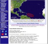
Keeping a weather eye to the East wouldn't be a bad idea over the next few days. There's a disturbance out there that has a forecast 80% chance of developing into a tropical cyclone over the next five days.

This graphic is from WeatherUnderground.
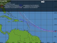
Capture.JPG


NHC Tropical Weather Outlook:

[h=4]Tropical Weather Outlook Text[/h]TROPICAL WEATHER OUTLOOK
NWS NATIONAL HURRICANE CENTER MIAMI FL
800 AM EDT TUE JUL 29 2014

For the North Atlantic...Caribbean Sea and the Gulf of Mexico:

1. Satellite images indicate that showers and thunderstorms
associated with an area of low pressure located about 1600 miles
east of the southern Windward Islands continue to become better
organized. This system could develop into a tropical depression
later today or tomorrow while it moves westward or
west-northwestward at 10 to 15 mph.
* Formation chance through 48 hours...high...70 percent.
* Formation chance through 5 days...high...80 percent.

Forecaster Pasch
 
Hoping it goes way north or no where at all except out to sea... I am flying to US via Puerto Rico on Sunday and don't want this in my path!
 
Must be something crazy weather-wise going on this weekend, Kevin......our son is in Chile, and he said it's been pretty quite, but looks like a big storm headed for the Andes this weekend! Snow for them, rain for the Caribbean.
 
The foliage here is turning yellow and brown and the rain is really needed. Let it just not be dangerous!
 
Must be something crazy weather-wise going on this weekend, Kevin......our son is in Chile, and he said it's been pretty quite, but looks like a big storm headed for the Andes this weekend! Snow for them, rain for the Caribbean.


Cool. A neighbor is off to Chile Thurs to ski. He'll be a happy camper...or skier...
 
From the NHC:

TROPICAL WEATHER OUTLOOK
NWS NATIONAL HURRICANE CENTER MIAMI FL
800 AM EDT THU JUL 31 2014

For the North Atlantic...Caribbean Sea and the Gulf of Mexico:

A well-defined low pressure system located about 650 miles east of
the southern Windward Islands has been producing organized shower
and thunderstorm activity during the past several hours. If this
activity persists, tropical depression or tropical storm advisories
will be initiated later this morning. Interests in the Lesser
Antilles should monitor the progress of this disturbance as it moves
west-northwestward at 15 to 20 mph, and watches or warnings may be
required for some of these islands later today. A Hurricane
Hunter aircraft is scheduled to investigate the system this
afternoon.
* Formation chance through 48 hours...high...70 percent.
* Formation chance through 5 days...high...70 percent.

$$
Forecaster Pasch
 
SPECIAL TROPICAL WEATHER OUTLOOK
NWS NATIONAL HURRICANE CENTER MIAMI FL
415 PM EDT THU JUL 31 2014

For the North Atlantic...Caribbean Sea and the Gulf of Mexico:

A Hurricane Hunter aircraft has continued to investigate the
low pressure system located about 500 miles east of the Windward
Islands. Observations from the aircraft indicate that this system
is producing winds of up to 40 to 45 mph in the northern portion of
the circulation. Showers and thunderstorms could redevelop over
the low tonight or Friday, which could result in tropical cyclone
formation. Regardless of development, winds of gale force are
likely to spread across portions of the Lesser Antilles beginning
early Friday. Interests in the Lesser Antilles should continue
to monitor the progress of this disturbance as it moves
west-northwestward near 20 mph, and watches or warnings may be
required for some of these islands later tonight or Friday.
* Formation chance through 48 hours...high...70 percent.
* Formation chance through 5 days...high...70 percent.

$$
Forecaster Pasch
 
Top